PILOT SITE 3
WESTERN BLACK SEA - DANUBE INFLUENCE AREA
ABOUT THE PS3
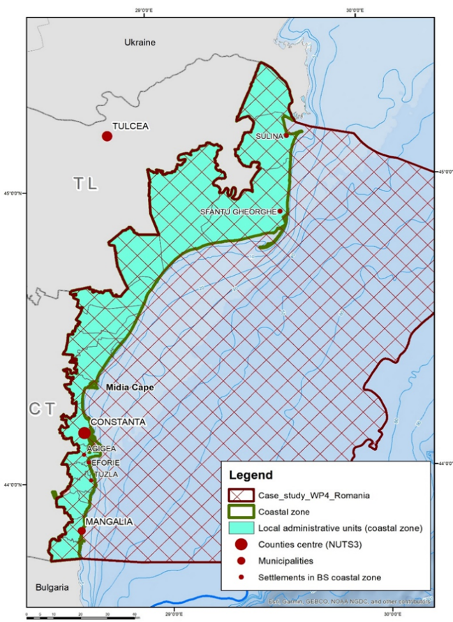
The Romanian coastal zone (PS3) spans approximately 18,500 km², including waters up to the 70-meter isobath within the Exclusive Economic Zone (EEZ) and related inland areas. Part of the NUTS 2 South-East development region, it encompasses Constanța and Tulcea counties (NUTS 3 level), covering 3,575 km² and housing 400,828 people in 2021—a 15% population decline since 2011. Its 245 km coastline, representing 6% of the Black Sea coast, stretches from Musura Bay in the north to the Bulgarian border at Vama Veche in the south. Predominantly natural (84%), the coastline features low-lying shores (80%) and cliffs (20%), shaped by wave dynamics, sediment transport, and climate events like storm surges.
Structurally, the PS3 coastline has two units. The Northern Unit (165 km from Musura Bay to Cape Midia) lies within the Danube Delta Biosphere Reserve, characterized by low beaches and gentle underwater slopes. The Southern Unit (80 km from Cape Midia to Vama Veche) is highly developed, with artificial beaches, limestone platforms, and coastal protection structures. The Danube River’s Chilia, Sulina (navigable), and Sfântul Gheorghe branches deliver nutrients, sediments, and contaminants to the Black Sea, shaping the region. Coastal erosion affects areas like Sulina and Perișor North, while sediment accumulates in Sulina and Cape Midia. Recent erosion control efforts (2011–2022) include dykes and beach nourishment.
The PS3 marine area, encompassing territorial waters, the contiguous zone, and part of the EEZ, features a nutrient-rich hydro-chemical structure and biological productivity influenced by the Danube’s Chilia plume. Tourism dominates the economy despite seasonality, with marine fishing extending to the 60 m isobath targeting species like turbot and mackerel. Aquaculture focuses on freshwater and brackish farming, with marine initiatives emerging. Coastal protection continues under the "Coastal Erosion Reduction - Phase II (2014–2020)" project. The Romanian EEZ contains 16 hydrocarbon exploration perimeters, with XVIII Istria currently operational. The Port of Constanța (Constanța, Midia, Mangalia) anchors regional port activities. Wastewater from ten treatment plants discharges into the Black Sea. Agriculture covers 134,000 hectares (37.55% of the area), while key industries, including petrochemicals and shipbuilding, are concentrated in the south.
KEY ECOSYSTEM SERVICES

PROVISIONING: FISH AND SHELLFISH

REGULATING AND MAINTENANCE

CULTURAL SERVICES: RECREATION AND TOURISM
SUSTAINABLE BLUE ECONOMY OPPORTUNITIES
KEY MULTI-STRESSORS
CLIMATE CHANGE
NUTRIENT LOADS

MARINE LITTER
ILLEGAL FISHING

INVASIVE SPECIES
BRIDGE-BS ACTIVITIES IN THE PS3

- BRIDGE-BS Expedition – NIMRD & GeoEcoMar – July 29 – August 3, 2022
- BRIDGE-BS Winter Cruise - GeoEcoMar and NIMRD - February 2-7, 2023
- BRIDGE Black Sea Summer Cruise - GeoEcoMar and NIMRD - June 8 – 13, 2023
- Three rounds of Living Labs were conducted, comprising on-site sessions held on 26 January 2022, 28 February 2023, and 10 April 2024. These sessions engaged around 90 participants from diverse blue economy sectors and local communities.
- The National Institute for Marine Research and Development “Grigore Antipa” hosted the BRIDGE-BS Macrozoobenthos Workshop on November 21-22, 2023, in Constanza. Partners from Romania, Bulgaria, and Georgia, including GeoEcoMar, IO-BAS, IBER-BAS, and TSU, discussed benthic habitat indicators, agreed on assessment methodologies, and shared updates on non-indigenous species and macrobenthic research.
- The Romanian Black Sea Young Ambassadors participated in MARBLUE 2022, engaging in productive discussions.
- They also led science outreach activities during Green Week on March 28, 2023.
- They organized events for European Maritime Day (EMD) in my country, including the Marine Research Open Day on April 6, 2023, and June 12, 2024.
- As part of the BRIDGE-BS, several events will be organized under the Responsible Seafood Consumption Campaign. PS3 partners will also extend the campaign through various EU, Black Sea, and locally-based activities to ensure broader dissemination and deeper public engagement.
- The Joint BRIDGE-BS and DOORS Special Session at MARBLUE 2024 was held, led by project partners NIMRD, Istanbul University, and HCMR, focusing on harmonizing research methodologies in the Black Sea. During the session, representatives from both projects presented their specific objectives, goals, and deliverables. The BRIDGE-BS team emphasized aligning research frameworks to enhance data analysis and reporting, while the DOORS team highlighted complementary goals focused on promoting interoperability and integration within broader marine data initiatives.
PARTNERS INVOLVED
