PILOT SITE 4
NORTHWESTERN BLACK SEA

ABOUT THE PS4
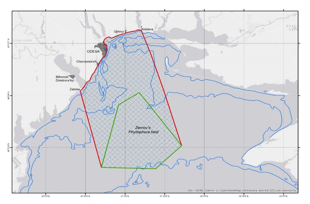
The coastline stretches across three distinct sections, all oriented in a general north-eastern direction. The first section, from Zatoka Point to Odesa Gulf (Yuzhnyi Cape), is 83 km long; the second, covering Odessa Bay from Cape Yuzhnyi to Cape Severny, spans 16 km; and the third, extending from Cape Severny to Koblevo Point, measures 45 km. In total, the landfill coastline is 144 km long, while the PS4 polygon covers an area of 9,870 km². The sea border itself stretches for 480 km.
Over the last decade, surface water temperatures have ranged from 2°C in winter to 22°C in summer, peaking at 30°C in recent years. Three estuaries—Dnistrovskyi, Sukhyi, and Ajalyk—are connected to the PS4 water area, with the northern and eastern regions influenced by the runoff from the Dnieper-Southern Boug rivers. Occasionally, wind-driven phenomena bring Danube River waters into the area, creating hydrological frontal zones. Salinity ranges from 4 to 19 PSU, and water circulation is cyclonic, primarily influenced by wind patterns, with average current velocity in the upper layer between 5-6 cm/s.
Human activities in the PS4 area, including uncontrolled wastewater discharge, agricultural runoff, and marine litter, have led to eutrophication and water quality deterioration. Military operations contribute further environmental damage, with toxic contamination from explosives, sunken vessels, and destruction of infrastructure like the Kakhovka Dam. Maritime activities, such as port operations, shipping, coastal construction, and tourism, have caused marine pollution and habitat destruction. Overfishing and offshore gas and oil extraction have depleted marine resources, while war-related hazards like military debris, acoustic pollution, oil spills, and barriers like the Kerch Bridge disrupt marine species migration.
KEY ECOSYSTEM SERVICES
REGULATING SERVICES

PROVISIONING

SUPPORTING SERVICES

CULTURAL SERVICES
SUSTAINABLE BLUE ECONOMY OPPORTUNITIES
KEY MULTI-STRESSORS
WATER QUALITY DETERIORATION

ACUTE POLLUTION

RESOURCE EXPLOITATION

INVASIVE SPECIES
CLIMATE CHANGE

MILITARY-RELATED PRESSURES
BRIDGE-BS ACTIVITIES IN THE PS4

- A study has been conducted on the impacts of military and civil activities on the PS4, including the consequences of the Kakhovka HPP dam destruction.
- Preliminary assessments are being carried out to evaluate changes related to military operations and combat activities.
- Weekly monitoring studies, focusing on hydrochemical and biological parameters, are conducted at accessible sampling stations. In 2024, 68 samples were collected to assess hydrochemical and biological indicators.
- Monthly surveys are carried out to monitor pollutant levels, including those from agricultural and industrial sources, as well as substances whose concentrations may be affected by military operations. In 2024, 20 samples were collected for pollutant concentration analysis.
- From 9 to 11 July 2024, the R/V Alemdar II, operated by Istanbul University, conducted a cruise to monitor the inflow of Mediterranean water through the Bosphorus.
- On 9 July 2024, a joint offshore intercomparison exercise for CTD and dissolved oxygen measurements was carried out by Istanbul University and METU.
- METU conducted four seasonal expeditions (2021–2024) covering the entire basin and PS1.
- BRIDGE-BS Living Labs 1st Workshop (2022): 17 participants (representatives of various stakeholder groups). Key outcomes included the identification of:
- Essential Ecosystem Services
- Risks and multi-stressors
- Challenges and needs for PS4
- Opportunities in the Blue Economy - BRIDGE-BS Living Labs 2nd Workshop (2023): 25 participants (representatives of various stakeholder groups). Key outcomes included:
- Definition of the LL Challenge
- Finalization of the Problem Statement
- Vision for the future of the north-western part of the Black Sea (PS4)
- The public is informed about the state of the Black Sea through official UkrSCES communication channels.
- Research results, theoretical conclusions, and assessments are communicated to the public through regional, national, and international media outlets.
- Ongoing monitoring surveys focus on hydrochemical and biological parameters, as well as chemical contamination.
- Thematic conferences are held for stakeholders, such as those addressing the consequences of the Kakhovka HPP dam breach.
- UkrSCES reported hazardous Red Tide in the Northwestern Black Sea. Read the report.


