PILOT SITE 6
EASTERN BLACK SEA
ABOUT THE PS6
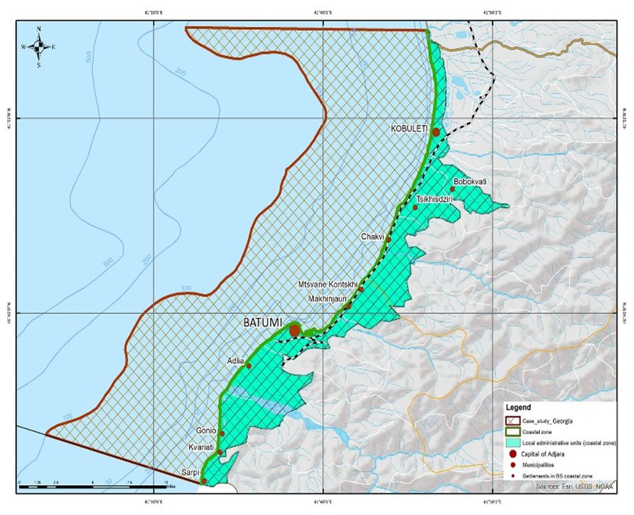
Georgia’s coastline stretches approximately 310 km, with over 150 rivers flowing into the Black Sea. The region’s coastal habitats include sedimentary shores, saline lagoons, estuaries, deltas, wetlands, and rocky shores.
The Ajara Autonomous Republic’s coastline extends 50 km, from the Georgian-Turkish border to the mouth of the Natanebi River. This arc-shaped section features sandy and pebble beaches, alongshore sand-pebble levees (modern and ancient embankments), and occasional steep rocky sections, such as in Tsikhisdziri, Mtsvane Kontskhi, and Kalenderi headland. The coastline is mainly formed by alluvial sediments, part of the Chorokhi morphodynamic system, and is divided into three sub-systems: 1) Kvariati-Batumi Cape 2) Batumi-Tsikhisdziri Cape 3) Tsikhisdziri Cape–Natanebi River Mouth
The seabed consists of three geomorphological elements: the continental shelf, continental slope, and abyssal plain. The shelf, occupying 24% of the sea area, extends from the coast to depths of 90–120 m, where the slope steepens sharply. Its width varies, reaching 200 km in the north and narrowing near the Caucasus and North Turkey. Along Georgia’s coast, the shelf is narrow, with a 160 m depth isobath, and Ajara’s coastline features areas with a 25 m isobath.
The continental slope, covering 40% of the seabed, ranges from 100 m to 2000 m in depth and features underwater canyons, including those of Batumi, Chorokhi, and Kintrishi. The abyssal plain, covering 36% of the seabed, is almost flat and lies within the 2000 m isobath.
KEY ECOSYSTEM SERVICES

FISHERIES AND AQUACULTURE
PORTS AND SHIPPING

TOURISM
SUSTAINABLE BLUE ECONOMY OPPORTUNITIES
KEY MULTI-STRESSORS
CLIMATE CHANGE
COASTAL EROSION
STORMS AND FLOODS
EUTROPHICATION
BRIDGE-BS ACTIVITIES IN THE PS6

Research stations, sampling depths, and chemical and biological indicators have been identified. Consequently, chemical and biological observations were conducted at five stations (see Table 1).
Table 1. Black Sea Ajara Zone Monitoring Information
| Station N | Station Name | Water Area | Strata | Depth (m) | Coordinates (DD) |
|---|---|---|---|---|---|
| ST1 | Kvariati_1 | Kvariati | <30 | 27 | N: 41° 56.3914', E: 41° 55.6864' |
| ST2 | Sarpi_2 | Sarpi | >30 | 47.5 | N: 41° 55.4417', E: 41° 54.8000' |
| ST3 | Chaqvi_1 | Chaqvi | <30 | 23 | N: 41° 71.5800', E: 41° 69.6750' |
| ST4 | Chaqvi_2 | Chaqvi | >30 | 39 | N: 41° 72.0650', E: 41° 69.1450' |
Table 2. The Black Sea Georgia Zone Monitoring Chemical and Biological Parameters
Chemical indicators/parameters | Biological indicators |
Temperature | Phytoplankton Total abundance cells/m3 biomass mg/m3 species composition |
Transparency | |
pH | |
TSS | |
Salinity | Mesozooplankton Total abundance cells/m3 biomass mg/m3 species composition |
Dissolved oxygen DO | |
Ammonia NH4-N | |
Nitrite NO2-N | |
Nitrate NO3-N | Zoobenthos Biodiversity number (ind/m2) biomass (g/m2) |
Phosphate PO4-P | |
TP | |
TN | |
Heavy metals - Fe, Zn, Cu, Ni, Mn |
|
Polycyclic Aromatic Hydrocarbons (PAHs) |
|
Organochlorine Pesticides |
|
Marine litter (riverine, beach and sea floating) |
|
Chemical indicators/parameters in sediments |
|
Heavy metals - Fe, Mn, Cr, Cu, Zn, Ni, Pb, As |
|
TPH |
|
TOC |
|
Onboard activities:
- Investigation of vertical distribution of T, pH, Sal;
- Water sampling for determination of dissolved oxygen;
- Water sampling for determination of dissolved inorganic nutrients;
- Water sampling for determination of heavy metals;
- Water sampling for determination of organic pollutants: PAHs, TPH, and Pesticides;
- Water sampling for the study of phytoplankton;
- Collection of macrozoobenthos samples;
- Collection of Mesozooplankton samples;
- Sampling sediments for the determination of heavy metals;
- Sampling sediments for the determination of TOC and TPH.
Water samples were transferred to the laboratories and analyzed according to the corresponding methodologies.
Marine litter monitoring program: The marine litter monitoring program includes investigations of beach, floating marine, and floating riverine litter. The methodology was developed in accordance with the European Marine Strategy Framework Directive and Guidance of the Joint Research Centre of the European Union JRC. The strategy of selection of marine litter monitoring sites was based on different criteria, aiming to identify the sources of pollution. The marine litter observation program was coordinated with other monitoring programs of the project.
Within the BRIDGE-BS Project, WP 5 activities under PS 6 involve the seasonal investigation of the Batumi City – Adjara Region coastal zone. The investigation focuses on four main tasks:
- Assessment of physical and chemical indicators of marine environment quality
- Evaluation of eutrophication levels in the Adjara Black Sea shelf and coastal waters
- Assessment of pollution levels in the Adjara marine area
- Evaluation of the state of marine biodiversity in the Adjara shelf and coastal waters
As part of the BRIDGE-BS project, four seasonal expeditions have been conducted:
- The first cruise took place in Summer – July 2022
- The second expedition was conducted in Spring – May 2023
- The third expedition was carried out in Winter – December 2023
- The fourth expedition is scheduled for Autumn – November 2024
Based on the results of the first three expeditions, metadata and intermediate scientific reports have been prepared and submitted. The results from the fourth expedition are currently being compiled.
On January 28, 2022, the first meeting with PS 6 stakeholders was held in Batumi in hybrid mode. Stakeholders from various sectors participated, including the Policy sector (Municipality and National Environmental Agency), Fishery, Aquaculture, Tourism, Ports, Academia, and NGOs. The meeting’s first session focused on identifying key Ecosystem Services (ES), resulting in the creation of a list of the most important ES. In the second session, risks and multi-stressors were identified. The third session, a Living Lab workshop, allowed local stakeholders to highlight the needs and opportunities within PS 6.
The second PS 6 stakeholders' meeting took place on May 17, 2022, in Batumi. During this meeting, a Mental Map and Future Narrative were developed, capturing both individual and group perspectives.
The third meeting was held on April 26, 2024, in Batumi. During this session, the steps for a transformative pathway were outlined, aiming for the practical implementation of the Future Narrative.
From November 5-7, Black Sea Young Ambassador Tatiana Sitchinava participated in the #PREP4BLUE Pilot Stakeholder Assembly on Marine Ecosystem Preservation and Innovation in Batumi. She shared valuable insights on youth-driven cross-border collaboration for a sustainable future, emphasizing the preservation of the Black Sea and Danube.
On November 15, Black Sea Young Ambassadors Marika Makharadze and Salome Kobaidze made an impact at the #ScienceOutreach event organized by Batumi State University and the Ministry of Education, Science, and Youth of Georgia. They highlighted the BRIDGE Black Sea project, the Black Sea SRIA, and its Implementation Plan, engaging attendees with quizzes, competitions, and other interactive activities.
Black Sea Young Ambassador Marika Makharadze contributed to the latest publication from the Food and Agriculture Organization of the United Nations (FAO) and the General Fisheries Commission for the Mediterranean (GFCM). As one of the featured interviewees, she played a key role in bringing gender equity in fisheries to the forefront of the conversation.
- On November 15th, an event organized by Batumi State University and the Ministry of Education, Science, and Youth of Georgia was held, featuring the BRIDGE Black Sea project, the Black Sea SRIA, and its Implementation Plan. During the event, scientists from various institutions shared their expertise with the youth through engaging activities such as quizzes, competitions, and more.
- In November 2024, the fourth and final scientific expedition of the year took place, marking the conclusion of the seasonal research. During this mission, chemical and biological samples were meticulously collected in line with the research plan. Additionally, investigations were conducted on beach, riverine, and floating marine litter, contributing valuable insights into marine pollution dynamics.
