PILOT SITE 7
SOUTHWESTERN BLACK SEA

ABOUT THE PS7
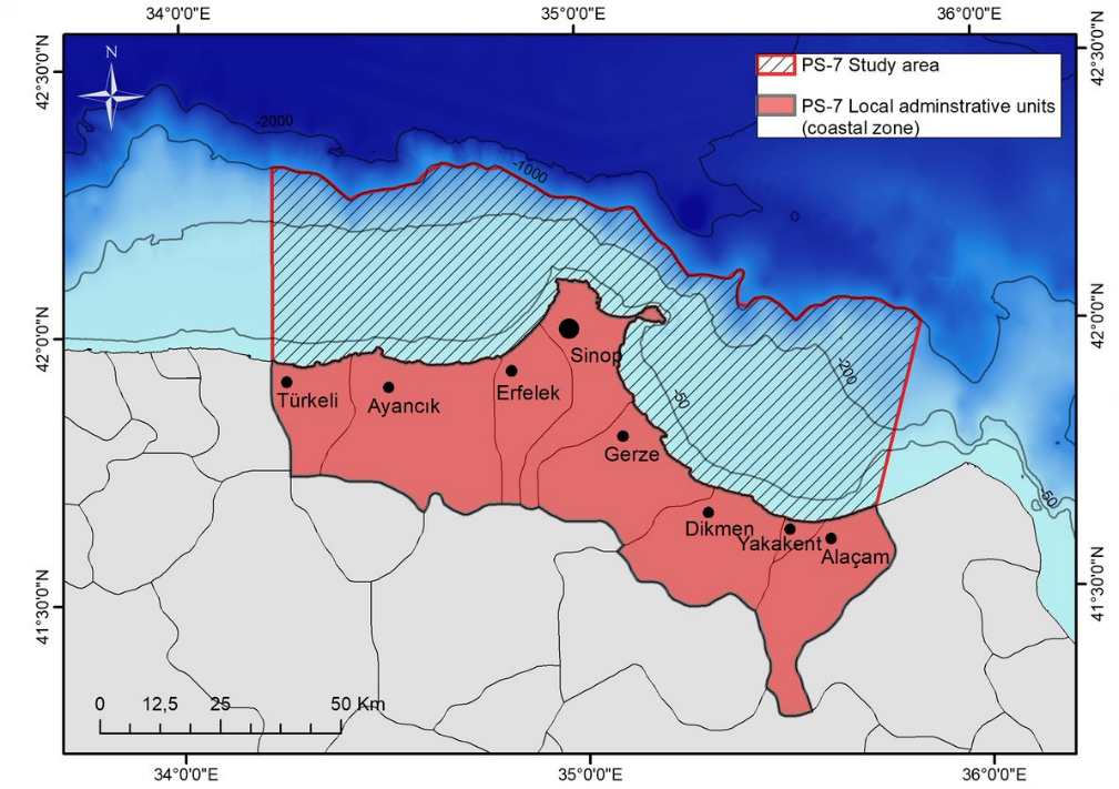
PS7 Southwestern Side, Sinop covers Turkish EEZ waters up to the 1000-meter isobath and includes coastal administrative units, representing an area of approximately 8640 km² (see map below). This coastline falls within the Marine Assessment Unit KARD3-Sinop of Turkey. The region is home to 8 municipalities (Sinop, Ayancık, Türkeli, Gerze, Erfelek, Dikmen, Yakakent, and Alaçam) and 2 cities (Sinop and Samsun), encompassing 3766 km². The total coastline length is 269 km, stretching from Türkeli in the west to Alaçam in the east, representing 3% of the Black Sea's total coastline (8350 km).
Sinop lies centrally along the Turkish Black Sea coast and marks the northernmost point of Turkey. The city is situated on the Boztepe Peninsula, which extends northward into the Black Sea. Compared to the steep southeastern Black Sea shores, the Sinop coastline is characterized by its relatively gentle, indented shores. Inceburun, located here, is the northernmost point of Anatolia. Notably, there are no harbors protected by bays or gulfs along the Turkish Black Sea coast from Hopa to the Bosphorus, except in Sinop. The region is known for its significant fishing and tourism industries, with minimal industrial pollution.
Human activities in the PS7 region include intensive industrial capture fishery, with aquaculture serving as a hotspot, particularly in three areas designated for net cage fish farming, alongside the recent introduction of mussel farming; additionally, coastal tourism significantly impacts the area, with the population swelling 4-5 times during peak months of July and August.
KEY ECOSYSTEM SERVICES

PROVISIONING: CAPTURE FISHERIES AND AQUACULTURE

CULTURAL SERVICES: TOURISM
SUSTAINABLE BLUE ECONOMY OPPORTUNITIES
KEY MULTI-STRESSORS

OVERFISHING

ACUTE POLLUTION

HABITAT LOSS
BRIDGE-BS ACTIVITIES IN THE PS7

- Three rounds of Living Labs were held in the PS7, bringing together over 70 stakeholders in total for productive discussions centered on local priorities and challenges in achieving a sustainable blue economy, while collaboratively envisioning a brighter future for the region by 2050.
- 3rd Living Lab was held in May 2024
- Phytoplankton sampling (and physical and chemical parameters of water column) were carried out in July 2024.
PARTNERS INVOLVED


